Mammoth/South All Patchy, Peak Nears

Convict Lake (9/27/17) Josh Wray
How did I miss Josh Wray’s report this past week? Somehow it got buried by a load of email. Just found it.

Rock Creek (9/27/17) Josh Wray
Fortunately, none of the areas south of Mammoth Lakes have neared peak, though all of them moved from Just Starting to Patchy. Here’s what he reported on Wednesday:
Mammoth Lakes Basin (8,500′) – Patchy (10-50-%)
Lake George (9,000′) –Patchy (10-50-%)
Mammoth Rock (9,100′) –Patchy (10-50-%)
Laurel Meadow (9,000′) –Patchy (10-50-%)
Convict Lake (8,500′) – Patchy (10-50-%) – Convict Lake is gorgeous right now. Golden willows have ringed the lake with lime-yellow color. Some of the smaller groves near the backside of the lake have turned orange. Convict Lake is on the edge of transitioning to Near Peak.

McGee Creek (9/27/17) Josh Wray

McGee Creek (9/27/17) Josh Wray
McGee Creek (9,000′) –Patchy (10-50-%) – Aspen near the pack station have begun turning. It’s best around late afternoon. Look for lots of lime and yellow.

Rock Creek (9/27/17) Josh Wray
Rock Creek (9,000′) – Patchy (10-50%) – Like many of the upper areas, Rock Creek is off to a late start. The color begins at level 7,500′, but is just starting there. The best color is seen above the Rock Creek Resort.
Foster Travel on California Fall Color

Foster Travel
Travel writer/photographer Lee Foster and I will be heading Outside on the Eastside starting on Monday to photograph and record fall color.
Lee has published many books on California and holds the distinction as the first travel writer to fully embrace and be truly successful in online publishing. Recently, he posted this article on California Fall Color.
Our route will take US 50 east to Placerville, then south along Mormon Emigrant Trail to CA 88, then east again across Carson Pass through the Hope Valley, turning south through Markleeville and over Monitor Pass to US 395.
From there, we’ll travel south, checking Eastern Sierra canyons for color, arriving at North Lake in Bishop Creek Canyon for the sunset.
I’ve been asked where the locations identified on this site are located, since many are not identified on Google or Apple maps. That is why I’ve placed a custom map on this website. You’ll find it in the column to the right, just below the weather forecast.

California Fall Color Map
The California Fall Color Map identifies precisely where fall color has been seen and to what stage the color has progressed. However, the updating of the leafs is done manually as new reports arrive, and I am sometimes delayed from posting updates. So, the map is only as current as time permits to post updates.
Still, if you’re reading this site and go to the map, you can find locations about which we’ve reported on this site.
To use it, click on the brackets at upper right. The map will open in a new window. Then search for the location you want to visit or click on a leaf. Expand the view to make clicking on leaves easier. You may have to click “View in Google Maps,” for a closeup view of nearby roads.
Good hunting.
Round Valley: Bigleaf Maple Go Big

Bigleaf maple, Round Valley Canyon (9/27/17) Jeff Luke Titcomb
Reporting from Plumas County, color spotter Jeff Luke Titcomb found bigleaf maple and dogwood showing Near Peak color in areas of Round Valley Canyon.
Round Valley Canyon (4,692′), Plumas County – Near Peak (50-75%) GO NOW!

Dogwood (9/27/17) Jeff Luke Titcomb
Bishop Creek Futures

Gold Pan – Clearview Stock | Dreamstime
This doesn’t seem to be the autumn to be investing in gold, at least up Bishop Creek. As, that commodity – among the aspen – is in short supply.
A call to Jared Smith at Parcher’s Resort this morning was disheartening, at least for the moment. He reported that the snow that fell last week knocked newly turned leaves from the aspen. And, he was “not impressed” by what is left, for now.
If you’ve missed Jared’s reports, its because he hasn’t been able to take pictures, as the battery charger for his Nikon D7000 is missing. So, travel writer/photographer Lee Foster and I will be traveling there on Monday to bring him one and see what we can capture in all the canyons from Bishop north to Mammoth Lakes.
If you’d planned to photograph or visit Bishop Creek Canyon this weekend, don’t put it off. There still will be beautiful color, but probably not up to “Ohmigosh, I can’t believe this is happening” expectations.

Groves at Cardinal Village (9/29/17) Rick Aeschliman
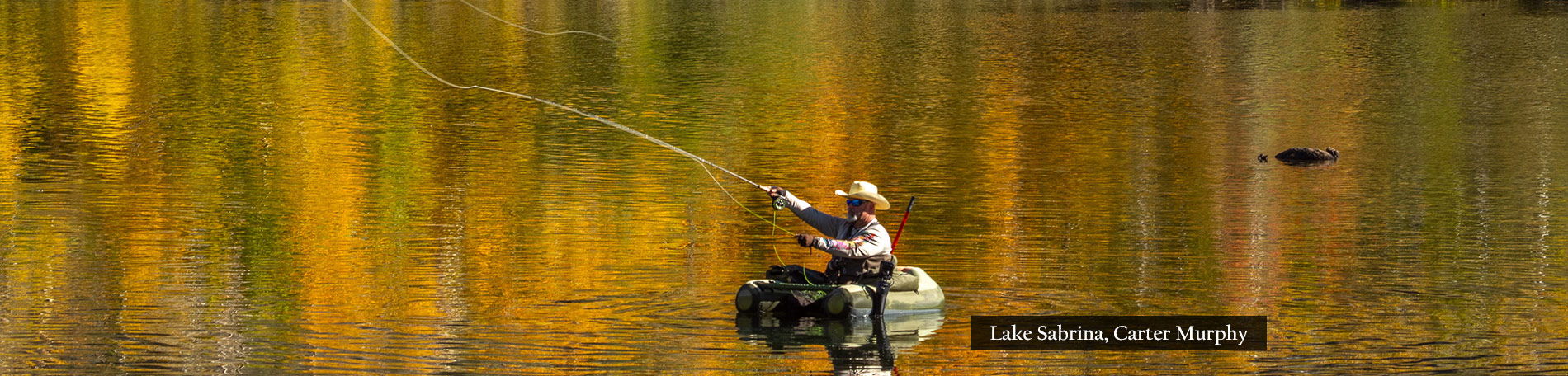
The best areas of fall color in Bishop Creek Canyon, presently, are: Lake Sabrina (high above the lake) and at Groves Above Cardinal Village (Near Peak). Most of the upper areas are patchy with muted orange and gold tones. Peak color can also be found near Mono Lake at Sagehen Meadows (use the California Fall Color Map at right for directions).
Though, do not let this limited selection discourage you from traveling. Fall color has progressed in Bishop Creek Canyon from patchy to full peak within a few days. Right now is when it has peaked in recent years, and at least two areas of the canyon are Near Peak, so GO NOW!
So, despite the disappointing reports, I’m not putting off my trip. I’m a Californian and we don’t get discouraged if we don’t find gold the first time we put a pan in the water. We just keep panning, as we know it’s there to be found.
Southern Inyo County
Whitney Portal (8,374’) – Just Starting (0-10%)
Onion Valley (9,600’) – Just Starting (0-10%)
Big Pine Creek (7,660’) – Just Starting (0-10%)
Mt. Whitney Fish Hatchery (4,000’) – Just Starting (0-10%)
Alabama Hills (4,534’) – Just Starting (0-10%)
Northern Inyo County
Weir Pond (9,650’) – Patchy (10 – 50%)
Sabrina Campground (9,000’) – Just Starting (0 – 10%)
Willow Campground (9,000’) – Just Starting (0 – 10%)
Table Mountain Camp (8,900’)- Patchy (10 – 50%) – Table Mountain and Surveyor’s Meadow seem to have the best color along South Lake Road, for the moment.
Surveyors Meadow (8,975’) – Patchy (10 – 50%)
Lake Sabrina (9150ft) – Patchy (10 – 50%) to Peak (75-100%) –Peak color is seen high above Lake Sabrina in groves of aspen growing near 10,000’. However, it has not yet descended to lake level. GO NOW!
North Lake (9,255’) – Patchy (10 – 50%)
Mist Falls and the groves above Bishop Creek Lodge (8,350’) – Just Starting (0 – 10%)
Aspendell (8,400’) – Just Starting (0 – 10%)
Groves above Cardinal Village (8,550’) – Near Peak (50-75%) – The stunted and weathered aspen here are normally notoriously early, but not this year. Presently, they are a deep orange color and should peak in the coming week. GO NOW!
Four Jeffries (8,000’) – Just Starting (0 – 10%)
Intake II (8,000’) – Just Starting (0 – 10%)
Big Trees Campground (7,800’) – Just Starting (0 – 10%)
Walker River Canyon Begins To Brighten

East Walker River (9/25/17) Robert Kermen

East Walker River (9/25/17) Robert Kermen
Color Spotter Robert Kermen was passing the Walker River (US 395) this week when he captured “just a little gold peaking out” among the willows and in the aspen along the canyon’s walls.
Walker River – Just Starting (0-10%)
Fall River Senses Fall

Ponderosa Pine, Willows, Spinner Fall Lodge, Fall River Mills (9/20/17) Martha Fletcher
Martha Fletcher of Fall River Mills (First Report) sends this shot of the tops of Ponderosa pine reflecting the orange glow of sunset, as – in the foreground – willows are just beginning to reflect on their own orange tones.
Fall River Mills (3,195′) – Just Starting (0-10%)
Sagehen Summit – GO NOW!
Fall color is developing rapidly across Mono County following last week’s storm, which dropped six inches of snow in the higher elevations of the Eastern Sierra, reports Mono County color spotter, Jeff Simpson.

Sagehen Summit (9/25/17) Jeff Simpson

Sagehen Summit (9/29/17) Rick Aeschliman
Sagehen Summit is Mono County’s first reported “GO NOW!” peak with vibrant yellows, and oranges. Simpson declares Sagehen Summit as a must-see this week. He estimates it will be photo-worthy for the next 5-7 days.

Virginia Lakes Rd. (9/25/17) Crys Black
Color spotter Crys Black drove south on US 395 from Conway Summit to Bishop Creek Canyon just after the dusting of snow this past weekend and found some color along the Virginia Lakes Road, though reported that the yellows were pretty muted. Similarly, Simpson says the upper sections of Rock Creek Road, Lobdell Lake Road and Tioga Pass are worth the trip, but still five days from peak viewing.

Convict Lake (9/25/17) Crys Black

Willows, Convict Lake (9/25/17) Crys Black
Convict Lake was starting to light up, though some leaves are spotty and brown. Black predicts the Round Valley to be good next week. Lots of its trees are frosted with yellow.
Convict Lake (7,850′) – Patchy (10-50%) – Willows are providing bright color around the lake.

Sagehen Summit (9/25/17) Jeff Simpson
Sagehen Summit (8,139’) – Peak (75-100%) – Sagehen Summit is currently displaying vibrant yellows, and oranges and is a MUST see this week and should be photo-worthy for the next 5-7 days. GO NOW!
Lobdell Lake Road (8,600”) – Patchy (10-50%) – Lobdell Lake Road is still having trouble getting going. Lots of green and lime green with not much change from last week Note: Burcham Flat Road to Lobdell lake Road are dirt roads – AWD or 4WD vehicles are recommended.

Virginia Lakes Rd. (9/28/17) Steve Greer
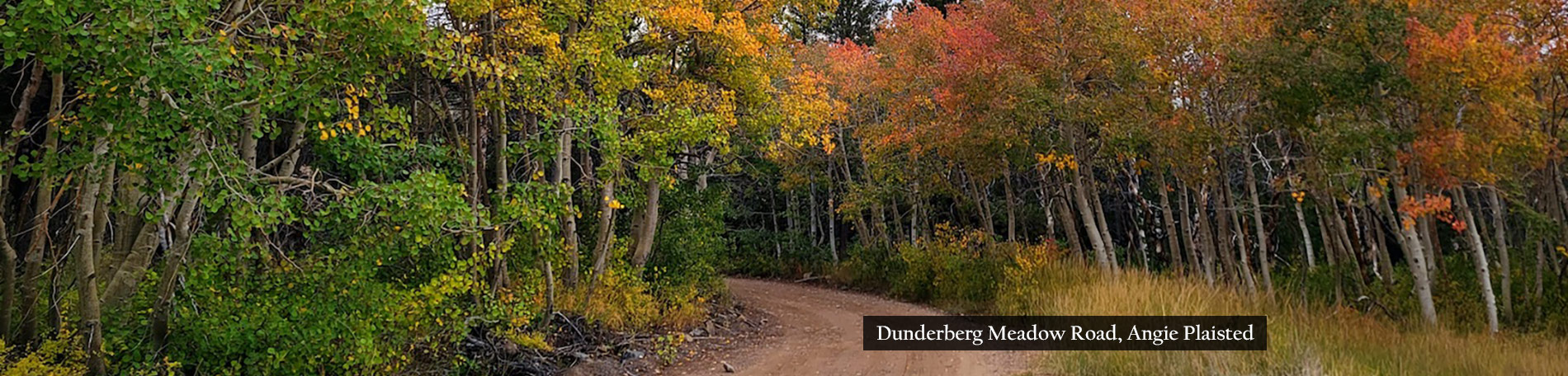
Virginia Lakes (9,819’) –Patchy (10-50%) – Yellow and greens around the lake with more color in higher elevations. For more adventurous leaf peepers with AWD or 4WD vehicles, take the Dunderberg Meadow Road to Sinnamon Meadows and Green Creek for additional aspen groves and views of Conway Summit.
Tioga Pass & Lee Vining Canyon (9,943′ & 6,781′) -Patchy (10-50%) – Color is just starting to show up around the upper elevations of Hwy 120 – Tioga Pass. Take the road up to Saddlebag Lake for the best viewing spots.
Upper Rock Creek (9,600’) –Patchy (10-50%) – Color is starting to show up nicely around Rock Creek Lake but still a bit patchy. Take the Mosquito Flats trail, Hilton & Davis Lakes Trail or Tamarack Bench Trail into higher elevations for more color.
Mono County is posting extended reports at MonoCounty.org and late pictures on Facebook.com/VisitEasternSierra and Instagram.com/MonoCountyTourism.
Via Preaches California Fall Color

Writing in Via, Christopher Hall declares, “To hear New England tell it, you’d think that glorious fall foliage only happens there. But we in the West respectfully disagree.”
Amen.
CLICK HERE to read his article.
Aspen Festival Returns to Alpine County

Hope Valley (10/8/16) Andrew Zheng
With only 1,138 residents, Alpine County is California’s smallest county, but what it lacks in population, it makes up in Quaking Aspen.
 Aspen forests populate seven viewing areas in Alpine County: the Hope Valley, Woodfords Canyon, Monitor Pass, East Fork Carson River, Ebbett’s Pass, Hermit Valley and Bear Valley/Lake Alpine.
Though Alpine County is just south of my base in El Dorado County, I’ve never scouted Ebbett’s Pass, Hermit Valley or Bear Valley/Lake Alpine. That’s an omission I hope to correct, and just might do so during the Alpine Aspen Festival, Oct. 7 – 8.
The festival occurs in the Hope Valley, which is a favorite destination for fall color spotters due to its proximity to Sacramento, Stockton, Modesto and the SF Bay Area.
Planned are interpretive hikes, photography and en plein air painting, a ranch tour, music and – of course – food (Dutch oven cooking and a feed benefitting East Fork Fire).
There are a bunch of first reports on the line. Let’s see who gets to them, first.
Liquidambar – A California Favorite

Liquidambar, Walnut/Diamond Bar (9/25/17) Del Hossain
Liquidambar styraciflua (Sweet Gum) is one of those ornamental trees that can’t wait for autumn to arrive.
It often begins exhibiting, bright reds, burgundies, yellows and oranges in flaming profusion in mid-summer.
More than any other tree, it generates reports that autumn is arriving early, just because it begins showing early fall color. Its brilliant color explains why it is one of the most commonly-planted deciduous trees.
The sweet gum is an American tree, though not native to California. It’s found growing naturally in the eastern and southeastern U.S., in Mexico and Central America.
There are 13 cultivars (a type of cultivated plant) of sweet gum (Burgundy, Festival, Gumball, Parasol… even the funny-sounding Goduzam and Morplesdon among them). In California, the Palo Alto is the favorite, appreciated for its flame color and autumn glow.
From Los Angeles County, color spotter Del Hossain was out for an evening walk last night. Inspired by an orange-purple sunset, he was further dazzled by the color within a liquidambar urban forest planted along Pathfinder Rd. that was exhibiting complementary color.
True to its reputation, while native trees are struggling to get going in the Sierra, the exotic liquidambar styraciflua is unashamed to blush early.
Diamond Bar (696′) – Just Starting (0-10%)