Sacramento Fall Color Comparisons: iPhone or Nikon?

William Land Park, Sacramento [iPhone or Nikon? – You Guess] (10/25/14) John Poimiroo

Mormon Island Wetland (10/25/14) John Poimiroo

Mormon Island Wetland (10/25/14) John Poimiroo
![Plaza Park, Fair Oaks [iPhone] (10/25/14) John Poimiroo](http://www.californiafallcolor.com/wp-content/uploads/JP-Fair-Oaks-10-25-iPhone-300x225.jpg)
Plaza Park, Fair Oaks [iPhone] (10/25/14) John Poimiroo
![Plaza Park, Fair Oaks [Nikon] (10/25/14) John Poimiroo](http://www.californiafallcolor.com/wp-content/uploads/JP-Plaza-Park-Fair-Oaks-10-25-300x214.jpg)
Plaza Park, Fair Oaks [Nikon] (10/25/14) John Poimiroo
![40th Ave., [iPhone] (10/25/14) John Poimiroo](http://www.californiafallcolor.com/wp-content/uploads/JP-40th-Ave.-2-10-25-iPhone-300x225.jpg)
40th Ave., [iPhone] (10/25/14) John Poimiroo
![40th Ave. [Nikon] (10/25/14) John Poimiroo](http://www.californiafallcolor.com/wp-content/uploads/JP-40th-Ave-10-25-300x214.jpg)
40th Ave. [Nikon] (10/25/14) John Poimiroo
![William Land Park, Sacramento [iPhone] (10/25/14) John Poimiroo](http://www.californiafallcolor.com/wp-content/uploads/JP-Land-Park-10-25-iPhone-300x225.jpg)
William Land Park, Sacramento [iPhone] (10/25/14) John Poimiroo
![William Land Park, Sacramento [Nikon] (10/25/14) John Poimiroo](http://www.californiafallcolor.com/wp-content/uploads/JP-Land-Park-3-10-15-300x214.jpg)
William Land Park, Sacramento [Nikon] (10/25/14) John Poimiroo
For this assignment, I carried two cameras, a Nikon D700 with Nikkor 28 – 300 3.5F AF lens and an iPhone 5S using Ollo Clip lenses (wide angle, fisheye and telephoto with polarizer). I’ve been experimenting with the iPhone on travel writing assignments.
Images shot with an iPhone photographs are not as sharp as with a full frame digital camera like the Nikon. Admittedly, I did not use a tripod which would have improved sharpness. And, the softness seen in these is exaggerated, because I used in-app filters. I use Adobe Photoshop’s iPhone app to filter my photos, as the resulting images are remarkably appealing.
I began Saturday’s trek in Folsom. While transiting town to US 50, I spotted golden crested cottonwood at Mormon Island Wetlands and pulled over to the curb on Sophia Parkway, shooting these two images with the Nikon while standing inside the Folsom city limits, proving that it isn’t necessary to drive hundreds of miles to find dramatic landscapes. They’re all around us when we’re observant.
Fair Oaks is a gentrified rural village outside Sacramento where roosters crow and have the run of town. None would cooperate for these photos of Plaza Park.
The American River has valley oak and black cottonwood that are still Just Starting.
The Fabulous 40s are tree-lined residential avenues in East Sacramento with landmark London Plane Trees (towering sycamore) creating canopies of leaf-heavy branches. The scene is lovely though overwhelming, so I sat on the curb to put the scene in perspective by photographing a pile of leaves in the foreground.
William Land Park is Sacramento’s great central park, with a golf course, zoo, children’s fairytale town, ponds, lawns and lots of trees. There are so many varieties of trees, that the color changes gradually from mid October through Thanksgiving day.

Pocket/Greenhaven, Sacramento [HTC Android] (10/26/14) Sharon Chew
Patchy – Sacramento County (10 – 50%) – Cottonwood and sycamore are showing lime, yellow and chartreuse throughout Sacramento County. Still, way short of nearing peak, though lovely none the less.
[weatherlayer country=”United States” city=”Sacramento”]
Indian Summer at Hot Springs Mountain

Indian Summer, Hot Springs Mountain (10/25/14) Scott Turner
Modern Hiker’s Scott Turner traveled out to Hot Springs Mountain in eastern San Diego County, yesterday to provide these images of the color change there and to inspire this article on Indian Summer.

Black Oak, Hot Springs Mountain (10/25/14) Scott Turner

Black Oak, Hot Springs Mountain (10/25/14) Scott Turner
Hot Springs Mountain is located on an Indian rancheria in eastern San Diego County. It’s a beautiful place, though remote, not very accessible and therefore not the kind of location most color spotters would venture.
That’s one reason we like Scott’s report so much. He repoted that black oaks are a lot further along than he thought they’d be. There’s a large mixed forest of oaks and pine on Hot Springs Mountain that are near peak.
Continuing to the Laguna Mountains, he found the higher elevations as patchy. Palomar Mountain and Julian are also patchy. Scott plans to visit them again next Friday and promises another report with photos.
Scott’s photographs of the hazy air hanging over Hot Springs Mountain on an Indian reservation made me wonder how Indian summer got its name. The answer may not be what you think it is.
What appears to be a well-researched report in The Mountain Eagle![]() says the condition of dry, hazy weather in October and early November dates back to the 18th century in the United States.
says the condition of dry, hazy weather in October and early November dates back to the 18th century in the United States.
Some believe the term evolved from the fact that native Americans would hunt then, as it was Indians practice to burn off underbrush for easier collection of acorns, a vital source of nourishment, accentuating the hazy and smoky atmosphere. The open forest also made it easier to hunt animals.
The Mountain Eagle said there’s an entirely different explanation, that has nothing to do with native Americans. During the 1800s, clipper ships were able to carry the heaviest when crossing the Indian Ocean during “Indian Summer,” as it was the fairest season of the year. To maximize what they could carry in their holds, the sailing ships would even mark “I.S.” on their hulls as the maximum load level thought safe to sail the Indian Ocean during Indian Summer.
Whatever the origin of the term, it is a pleasant time of year spent, most pleasantly, outdoors enjoying fall color.
California Fall Color Glows High Above US395

South Fork Bishop Creek (10/25/14) Janek U

Aspendell (10/25/14) Janek U

Aspendell (10/25/14) Janek U
Color spotter Janek U wrote that he traveled to the Eastern Sierra from Orange County, yesterday, stopping twice along the way along US 395. We receive many reports from Bishop Creek Canyon and points north, but were most interested on his report of what he saw south of Bishop, as few spotters have reported about those areas (tip: the fastest way to get a photo or report posted is for it to be about an area from which we don’t receive many reports).
Janek reported that at Lone Pine, he drove up to Whitney Portal. “There is some color on the peaks on the way up but they are too remote. There are also some groves of aspens near the road but there aren’t too many trees. He continued north to Bishop Creek Canyon finding the last of the color at Aspendell, noting that “The tops of some trees are beginning to turn red.”
Aspen Flicker, As Autumn Wanes at Aspendell

Aspendell (10/24/14) Yin You

Aspendell (10/24/14) Yin You

Aspendell (10/14/14) Yin You
As the last of the aspen drop leaves up Bishop Creek Canyon, we received these images today from Yin You and Jim Hemming’s video of his recent visits to the Eastern Sierra. CLICK HERE.
Driving Tour of Plumas County

Frenchman Canyon (10/23/14) Chuck Viebrock
If you don’t check back to read comments, earlier this week Sharon wrote that she was planning a trip this weekend to Plumas County and asked what advice we might offer. Here’s the touring guide to Plumas County that we recommended:
- Drive to Truckee on I-80, then north on CA-89/CA-70 to Quincy. There will be spots of color along the road. Greenhorn Creek parallels the road. As you approach East Quincy, the La Porte Road is often cited as a location where good color is found. Follow the La Porte Road south to Nelson Creek where good color has been reported in past years. The Quincy-La Porte Road is also good, heading toward the town of La Porte. Color spotters report the best color in Plumas County is found off highway. That would require an SUV in some cases, an ATV in extreme cases (USFS service roads), but a normal car in most cases. Plumas County is laced with old roads that follow streams. That’s where you’ll find some of the county’s best color. Indian Creek, is one. Though, you’d need time to explore the backroads and if you don’t have it, continue on to Quincy. In the town of Quincy are many exotics: the famed Judge Thieler sugar maple (now past peak) and lovely trees around the Murray home. This is more like shooting in New England, where architecture and foliage combine, though the architecture here isn’t as old or as classic. Plumas County used to have an excellent visitor center whose proprietor, Suzi Brakken, would come out and wash the windshields of leaf peepers. The county defunded support to that organization, so try the Quincy Chamber of Commerce for local advice. Karen Moritz of Plumas County also recommended taking “the short trip (17) miles up to Bucks Lake – west of Quincy. Lots of aspen, dogwood and bigleaf maple just off the highway.” Beyond Quincy is Indian Valley and Greenville. There’s often lovely color along the streams leading into the valley. The trick is to know the streams at which there’ll be color (the Indian Valley Chamber in Greenville may have advice). Look for brilliant orange Indian Rhubarb along the edges of creeks. I haven’t found the area beyond Greenville and Indian Valley to be that productive, though there are black oak and bigleaf maple on the west shore of Lake Almanor. So, once you reach Greenville, you might want to turn back and head down CA-70 toward Paradise and Oroville. There is Indian Rhubarb at the top of Hwy 70 (Feather River Canyon) and some bigleaf maple, though the farther down you go, the color will diminish. Paradise and Oroville further down Hwy 70 are just starting. So, the lower you go down the canyon, the less you will see as most of the Shasta Cascade is patchy for the moment.
- The second approach is basically the reverse of what we just described. Get to Hwy 70, then follow it up to Greenville, then backtrack along Hwy 89 through Quincy toward Truckee. You’ll find the best color on side trips to La Porte, Bucks Lake and other spots away from the main road.
- For another trip or a longer stay, eastern Plumas County can have great color in late October at Antelope Lake, along Babcock Creek and in Squaw Valley (not the ski area).
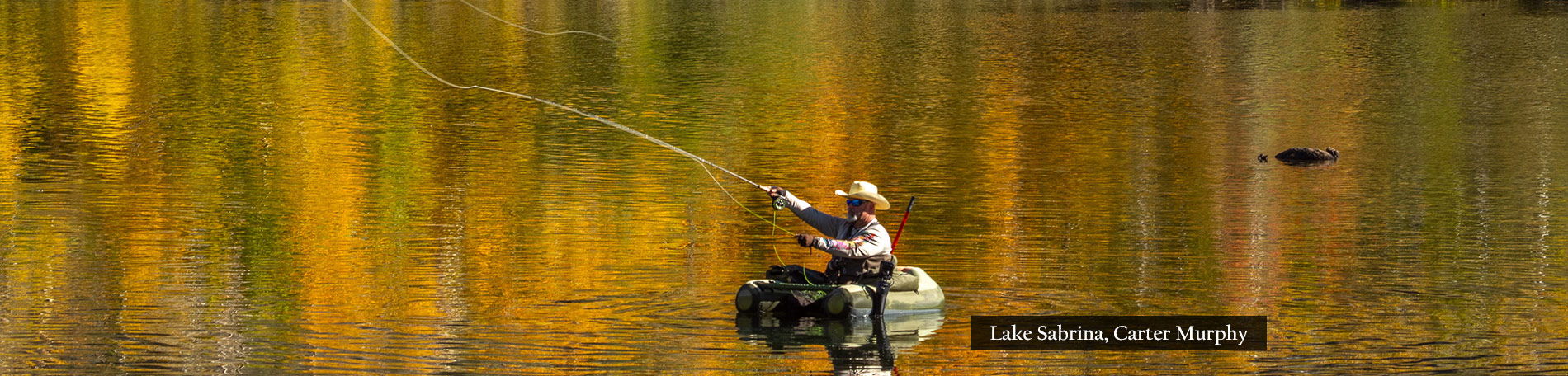
Travel Writer Lee Foster Describes US 395 Fall Color

Lake Sabrina (10/4/14) Lee Foster
Travel writer and photographer Lee Foster provides his perspectives on fall color viewing in the Eastern Sierra in his blog, FosterTravel.com. To read Lee’s article, CLICK HERE.
Hike of the Week: Gull Lake Trail

Gull Lake (10/22/14) Elizabeth Erdelyi
Located a few blocks north of June Lake Village (Hwy. 158) in Mono County, this lovely, scenic trail begins at Gull Lake Park (across from the June Lake Library) and loops around the shoreline of Gull Lake for an easy 2-mile jaunt. The trail meanders through glowing aspen groves at the west end of the lake, up a rocky bluff, and through the peaking aspens of Gull Lake campground. Peaking now with some sections past peak and some still lime green! CLICK HERE for more information.
Aerial Eastern Sierra
Keith Lake flies over the Eastern Sierra in these videos of Mammoth Lakes and Bishop Creek Canyon, posted last week.
[embedplusvideo height=”450″ width=”600″ editlink=”http://bit.ly/1tkZ1de” standard=”http://www.youtube.com/v/UiF3rjmhHSw?fs=1&vq=hd720″ vars=”ytid=UiF3rjmhHSw&width=600&height=450&start=&stop=&rs=w&hd=1&autoplay=0&react=1&chapters=¬es=” id=”ep2159″ /]
[embedplusvideo height=”450″ width=”600″ editlink=”http://bit.ly/1tkYuIt” standard=”http://www.youtube.com/v/rRLszfzPYCE?fs=1&vq=hd720″ vars=”ytid=rRLszfzPYCE&width=600&height=450&start=&stop=&rs=w&hd=1&autoplay=0&react=1&chapters=¬es=” id=”ep6474″ /]
Northeast California Moves From Patchy to Near Peak

Susanville (10/14/14) Joel Rathje
Quite a bit of color developed in the Shasta Cascade this past week, with three of its eight counties now almost Near Peak. The Shasta Cascade straddles the Southern Cascade and Northern Sierra mountains, which have shared foliage, though different wildlife.
The gorgeous photograph taken by Joel Rathje (above) shows the diversity of color now developing in the forests of northeastern California. The Shasta Cascade’s show is more subtle and painterly with brushes of yellow bigleaf maple, rosey dogwood, burnt umber California buckeye, orange-yellow black oak, golden cottonwood, chartreuse wild cucumber, orange-red Indian rhubarb and burgundy Oregon grape.
Bizz Johnson Trail (10/19/14) Stan Bales
Lassen County (Near Peak 50%-75%) Lassen County has begun to show vibrant yellows bigleaf maple and red dogwood. The Bizz Johnson trail is flanked with fall colors. GO NOW!

Greenville (10/14/14) Jeff Titcomb
Plumas County (Near Peak 50%-75%) If you plan to see Plumas County at peak, don’t wait much longer. Plumas is near peak with vibrant red and yellow scattered throughout the county. Quincy is at peak. See “Comments” for a guide to touring Plumas County. GO NOW!
Siskiyou County (Near Peak 50%-75%) With cooler weather descending into Northern California, Siskiyou County should also be at peak by Halloween. The color is particularly impressive when set against the backdrop of snow-covered Mt. Shasta which received a few inches within the past week. GO NOW!

Anderson (10/19/14) Brittany Pozek
Shasta County (Patchy 10%-50%) Shasta County is seeing patches of red and orange throughout the county. Most trees are starting to change and, with cooler weather making its way in, they are expected to peak at the end of October. Most trees in the Anderson area are still green with patches of red and yellow. Big changes are predicted in the next two weeks.

Aspen, Lassen County (10/14/14) Joel Rathje
Trinity County (Patchy 10%-50%) Trinity County is almost at near peak and predicted to show in early November. The historic town of Weaverville on Hwy 299 is a favorite fall color destination, with yellow bigleaf maple and chartreuse wild cucumber along the Trinity River.
Tehama County (Patchy 10%-50%) Tehama should be at near peak by the end of the month. River towns such as Cottonwood and Red Bluff are now having their riparian parks populated with reds and yellow oaks and willows.

Bidwell Park, Chico (10/19/14) Amanda Secrest
Butte County (Patchy 10%-50%) The urban forests of Chico are almost near peak. Chico’s Bidwell Park, the Abbey of New Clairvaux in Vina, walnut orchards along Hwy 99 and the foothill community of Paradise are prime locations to see peak around Halloween.
Modoc County (Patchy 10%-50%) Modoc County approaching near peak. Locals are predicting it will peak in early November. Cooling temperatures have intensified early shows of vibrant yellow and red.
[weatherlayer country=”United States” city=”Redding”]
Fall Hikes With Your Dog

Dogtrekker.com
DogTrekker.com is devoted to dogs, their owners and finding companion-filled fun in the great outdoors and on the road.
This week, editor Janet Fullwood described hikes to take in Mendocino, San Francisco, Lake Tahoe, Santa Barbara and Redding, several of which are along fall-colorful trails. Thanks DogTrekker for also giving a nod to CaliforniaFallColor for our fall color reporting.
As reported here previously, CaliforniaFallColor is a proponent of putting “pieds” to path and what better way to do that, than with your pet? Of course, finding trails that are open to dogs, that allow off-leash hiking and that include an uplifting view or destination can require a bloodhound’s nose.
So, before I grab their leash and say to Murray and Ditto, “Let’s go for a walk!”, I turn to DogTrekker.com or ModernHiker.com for good advice on dog-friendly trails.